
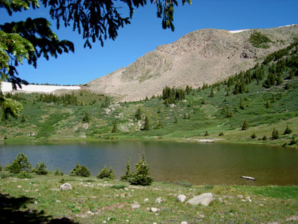
Archuleta Trail #839
This is a Weminuche Wilderness access trail and is therefore closed to all motorized vehicles.
See some wonderful photos on this blog:
http://poppypundit.wordpress.com/my-colorado-adventure-2007/
- Stream/Creek
- Location: Archuleta Trail #839
- Elevation: 9200-12200
- Commonly Caught Species: Cutthroat Trout
- Suggested Bait: Flies
- Restrictions: Must have Colorado Fishing License to fish. Trout must be returned to the water immediately.
- Fishing Method: Flyfishing
- Seasonal Accessibility: Late Spring/Summer/Fall
- Seasonal Accessibility Notes: Open year-round but usually snowed in from October through May
- Access: HorseBack, Hike
- Driving Directions: From the city of South Fork, travel west on US Highway 160 for 11 miles. Turn right on Forest Road 410 and travel west to Big Meadows Reservoir. Take the right fork below the Reservoir to the Boat Ramp. Park here to access the trailhead.
- Hiking Directions: The trail leaves from the Big Meadows boat launching area. Travels approximately 7 Miles along Archuleta Creek and the South Fork of the Rio Grande River, and joins the Continental Divide Trail at Archuleta Lake. It is a gentle trail and quite scenic along the lower end as it follows the South Fork of the Rio Grande River. The trail then climbs much more steeply. Much of the trail along this upper portion passes through Spruce and Fir stands and the views are intermittent until Archuleta Lake is reached.
- Handicap Accessible: Yes
- Forest Service Info:: https://www.fs.usda.gov/recarea/riogrande/recreation/fishing/recarea/?recid=28896&actid=43
Comments powered by CComment